

Utah Trip 2019
After years of saying I would make a trip out west to do some hiking, I finally got the change at the end of September. The stars aligned that I would be in Salt Lake City, Utah for a conference the week before Labor Day. Seeing as the conference ended on Thursday afternoon, that would give me three full days to enjoy hiking and get a test of what Utah had to offer.
I’m blessed to have friends in Utah and one of them is an avid hiker and photographer. After a little research, I decided that I would like to enjoy the alpine playground that are the Uintas. It looked completely in contrast to what I was used to back on the east coast.
Thursday Evening
Twink Lakes
After picking up the rental car from the airport, I headed to REI to grab a fuel canister in case I decided to backpack over the weekend. Situated as the base of the Wasatch Mountains, it was the most aptly placed REI that I have ever seen. Stepping out of the store and staring at the mountains, one could not help but want to sling a pack on your back and hit the trail. Before meeting my friends for dinner, he recommend a nice trail loop to get a taste for some of the terrain and also to see how the elevation would affect me.
Heading into Big Cottonwood Canyon, I headed toward the Brighton ski resort area to tackle the Brighton Lakes Loop. Parking at the Silver Lake trailhead, I switched from the last remnants of conference mode to hiker trash. I actually didn’t fall the original route but headed out toward Lake Solitude and then up the service road to overlook Twin Lakes. Dropping down to Twin Lakes, I cut across to Lake Mary and then back down toward the road to complete the loop. It was a nice five mile loop though it was nothing compared to the Uintas that I would be spending the next three days.
Friday
On Friday, we headed to the Uintas for a day hike and introduction to the area. Coming from the East, I can say that I was a little jealous of the ease of access to the Wilderness area. It was an hour from Salt Lake City to reach the boundary with a nice paved road running throughout the entire area. I am used to having to use some gravel / dirt forest service roads to access some of my trail.
Hayden Peak from Ruth Lake
Looking back toward Bald Mountain and Reids Peak
Though the pictures try to capture it, they fail to truly capture the beauty of the area. It actually was too much to process on this hike - a true impact to the senses. I could not describe what I was seeing and the smell was amazing - so clear and crisp along with the pines adding a little bit of Christmas tree lot smell. If you stopped hiking and just listened, you heard nothing.
Starting from the Ruth Lake Trailhead with Hayden Peak looming over us, we set off with our little squad (my friend, myself, and his two huskies). The plan was pretty fluid for the day - we were at least going to go up and see Lofty Lake but we would see where the trail would take us. After reaching Ruth Lake, we circled around it and then headed up to the pass to meet the Lofty Lake Loop. We decided to head clockwise down to see Scout Lake and then back uphill counter clockwise on the loop to Lofty Lake. As we got over 10,000 feet, the views down to the valley below just kept getting better. After reaching the saddle between two unnamed peaks (they are numbered), I got my first glimpse of Lofty Lake. It is a serene alpine lake with nice rocks to sit and watch the day go by (we didn’t take advantage of those due to a later start to the day). After circling the lake, we continued to lookout over the valley below and then it was decision time. We could continue along the loop which would drop us down to Kamas Lake or we could go overland and route find our way back to the car.
Descent to Lofty Lake
A word about route finding - it is not something you want to take lightly. In the east, it would be next to impossible do route find without a map and compass or GPS. You cannot see the mountains to get a bearing due to the tree cover and bushwhacking can be very difficult. As this is my first experience in the west, I’m not going to claim I’m an expert. It is a little easier since you can see the mountains around you and have a pretty good line of sight. Additionally, I was with a local who hikes this area all the time so he was familiar with this route and ultimately where we needed to end back up.
Campers at Ruth Lake
We broke from the loop at the point (turning right instead of left) and dropped down toward Cutthroat Lake and began finding our route back to Ruth Lake with Hayden Peak and that unnamed peak as our bearing points. We eventually passed Hayden Lake with a small boulder scramble and finally caught our glimpse of Ruth Lake. We could see more tents setup as we returned to the lake; the holiday crowd were starting to arrive. After taking a slight break to enjoy the last bit of the trail for the day, we head back to the trailhead and back to Salt Lake.
Saturday
Crystal Lake
Saturday was my chance to fly solo. After talking with my friend, we decided the Island Lake was probably the best backpacking trip for me concerning the crowds of the weekend, the distance, and my exposure to the elevation. I would be starting from the Crystal Lake Trailhead which was full when I arrived so I started the hike from overflow parking almost three quarters of a mile away from the trailhead though it was most likely a nice walk through the woods so I was happy with it. Crystal Lake was only two tenths of a mile from the trailhead so it was an excellent chance to get some pictures and start the trek toward Long Lake.
Cliff at Cliff Lake
Unlike the day before, there was very little cloud cover this day. Doing something I would never do back east, I put my buff on in hood configuration to block the sun from my ear and neck. I already had sunscreen on but the extra protection was nice and it actually kept me a little cooler. On the way to Long Lake, I decided to spur off and make a quick in and out to Cliff Lake. The out was entirely uphill which added a little bit of a workout but it was a nice reward to see the lake and knowing the back was all downhill to the main trail.
Views from the trail
Usually, I am laser focused on making miles when I’m backpacking because I’m trying to push to a particular point. Being that it was only supposed to be three and a half miles from the trailhead to Island Lake, I was trying to slow myself down and enjoy the moment (something that I need to do more in life). The ability to look around and see the various peaks (Mountain Watson, Haystack Mountain, and the multiple peaks of Long Benchmark were visible through most throughout the hike) from the multiple rock fields are a new experience. Long Lake was probably most favorite lake to photograph just because of the length and the peaks that surrounded it. After crossing Long Lake Dam, I managed to get a little off trail. It is pretty much a rock field for the next mile so it is looking for lined up rocks or cairns. From my GPS, I was still heading in the right direction to I continued making progress.
Long Lake
First view of Island Lake
I reached a point where I couldn’t seem to get back on the trail that ran directly to Island Lake. It was off to my right but there wasn’t an easy path back to it without backtracking. I decided to drop down and route find my way to link up to the trail that ran to Weir Lake since that would link back up with the Island Lake trail. This would also have the benefit of allowing me to see Duck Lake along the way and I still had plenty of time in the day. After linking up with the Weir Lake trail, I had no issue sticking with this trail and quickly linked up with the Island Lake trail once again.
Relaxing by the water
You arrive at Island Lake by popping over a rise. It is a very pretty lake with plenty of options for camping along it. There is also a cliff that you can jump off into the lake - there were a few people already at the lake enjoying this feature. It isn’t something that I would take advantage of because I’m too afraid of water being shallow and also being solo. It was around three in the afternoon so I set up camp and then decided to chill by the lake for a little bit. I even had a brief dip in the freezing water.
Campspot
As I’ve mentioned several times on the blog, I am still working on being confident staying in the woods by myself. I can day hiking remotely without any issue but as soon as I setup camp, my mind starts to whirl. Some of this is just worrying but it is also out of caution since I am solo and anything that would threaten my ability to get out the next day or my health overall. On this trip, I got a little concerned that I was consistently thirsty even after drinking properly while hiking and while at camp. Additionally, my resting heart rate was being really slow to come down and pretty much would not go below 100. As soon as I got up to go get water, it would start to climb again. To add to all of this, I had a little bit of a cough. Since I’m not used to the elevation, I thought that it might be a contributing factor. What I didn’t think about at the time was the dust from the trail and the lack of humidity which was affecting me. Though I did not know it at the time, I also picked up a cold while at the conference since everyone that went on that trip came back with.

Mule deer on the way out
All of this combined, after three hours at camp, I decided that I would play it safe and hike back out. I knew I had about two hours of sunlight left which be enough time to get back to the car safely. So I quickly packed up camp and headed back toward the trail head. The trail was much easier to follow heading back toward Long Lake (I found where I had gotten off trail next to the dam on the way back). Just before I got back to Crystal Lake, I got to see a mule deer about 30 feet in front of me. Overall, it was the best call for me to make and it set me up for a wonderful Sunday day hike.
Sunday
Hayden Peak
For Sunday, it was another day hike on the books. My friend’s cousin was in town and was looking forward to exploring the Uintas for the first time. Based upon experience, it looked like the Ruth Lake trail was the best way to judge how she would handle the elevation and then go from there similar to how I did on Friday. After a wonderful brunch, we (my friend, his partner, his cousin, and myself) drove out to the trailhead and hit the trail. The crowds were slightly oppressive during that first section to the lake. However, they started to die down as we made our way up to Lofty Lake for a snack by the lake.
Reids Meadow
Based upon the group’s decision, we decided to continue along the loop trail and get off at Pass Lake while my friend went back to get the car and pick up at the trailhead. After splitting up, our group dropped down to Kamas Lake which was another beautiful alpine lake. We also got to pass by Reids Meadow with a wonderful view of Reids Peak and then back to the trailhead. By this point, I was embracing the slow it down mindset and enjoying just being with people who shared the love of the backcountry.
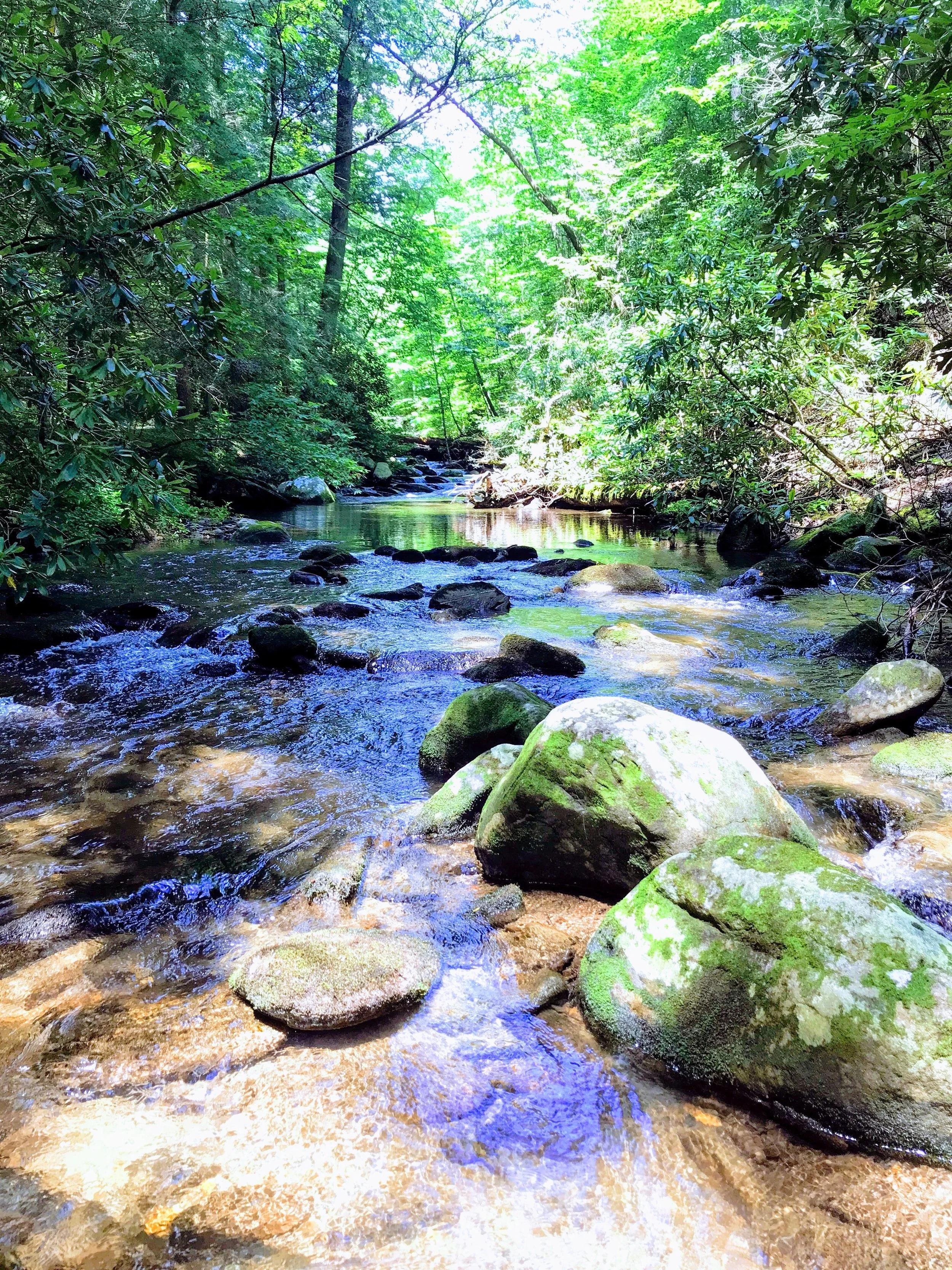
As final parting gift, we drove out to Christmas Meadow to catch the sun's last light dance across the mountains while listening to the river in the background. We piled back into the car and headed back to Salt Lake as I had to be up early to catch my flight back home.
Christmas Meadow


